Coed Brenin Enduro 2014

Coed Brenin Enduro 2014

Sunday, 15 September 2013

The JMT Part 3 - Reds Meadow to Muir Trail Ranch

Trail names:  I'd heard that people on the big hikes like the PCT (2600 mile) have/use trail names, for example a guy from Kendal uses milky (he's a milkman!). You can assign (!) yourself a name or be named by others on the trail. We met ipod at VVR (thanks for the bars man), Snort (she snorts when she laughs apparently) and Huff and Puff (a great couple who huff and puff as they hike uphill - brilliant). Coming from the UK this practise is a little strange, but on reflection I like the sheer child like fun of it. I guess some are forming an alternative trail identity, importantly how they wish to be interpreted with these names. Maybe also it links into the escapism and simple existence that you experience on the trail too. I'd love to study the sociology of it. We gave ourselves joke trail names but didn't really use them, for example Abi was Nose Bleed, because she kept getting nose bleeds, and one of us was Potty Mouth, but that's another story.....

Anyways (like how I did that? Anyways, now I'm not sure if it is more American or Canadian - I'd need a local to let me know?!). Anyways, back to our hike.......

From Red Meadows we waddled uphill (double cheeseburger) to Deer Creek through an area previously burnt out by fire. Deer Creek was reasonably busy (4-5 parties) because its a natural place to camp (by water, next water 5 miles). A family with 2/3 children (can't remember!) and 2 horses also arrived and camped, heading North on the JMT. We drifted off to sleep listening to the horses bells jingling all night long (I guess to warn bears).
Leaving Reds Meadow, going through an area previously burnt by forest fire

Camp at Deer Creek

The next section was great, a long traversing path (?5 miles) with great views over the range. Lake Virginia was of particular note on this stretch of the trail. Its also very spectacular when you suddenly arrive at a vantage point overlooking the Tully Hole (meadows) far far below. Eventually we camped after big  metal bridge with great views of a massive pyramid shaped mountain that appeared to have cool (but hard) climbing on it (must look it up!).
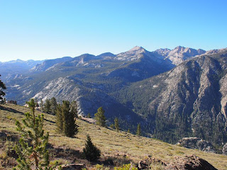
The great panorama trail


Lunch stop at Purple Lake

Lake Virginia, the views opened out here
Camp in the spooky woods after the metal bridge/Tully Hole

Last evening light on the mountain
Heading up to Goodale Pass next day

We'd heard at Reds that the ferry at Edison Lake had stopped running 10 days earlier, which would have meant another 5 miles on top of our 12 mile day to get to Vermillion Valley Resort (VVR) for our first and only zero day (American term for a rest day - you go zero miles!). Because of this it made much more sense (more direct) to go over Goodale Pass as we'd heard from numerous people that the walk along Edison Lake (now drained for the year) was a slog. This was a beautiful route, once off the JMT the trails got quieter, wilder and less well maintained. I'd love to know the story behind the Graveyard Meadows area that we passed through (anyone?).
Spooky but beautiful graveyard valley

Lunch time (peanut butter again)
Arrived at VVR a broken man after a 15 mile day (tired +++). What a cool place, an oasis for the weary hiker. After pitching the tent we opened a tab and had a delicious meal. Worth the the detour for sure and we were all ready for a rest day here. With the boat not running to get back on route we could either hike the lake shore (horrid), go up Bear Ridge (everyone said it was hot, shadeless, no water, no fun) or go up Bear Creek. We did the latter and the trail went up a great verdant valley with plunge pools in the river and plenty of shade (it was mega hot). Unusual weather, with a fogginess due to the smoke from the rim fire, hazing out the hills.
Finally a zero (rest) day at VVR


Cool signs
Lake Edison (drained) - wheres all the water gone....

This next section should again be called the 'Lake Distict', one beautiful lake after another as we crossed Seldon Pass (10,900ft) and started the 3400ft descent to Muir Trail Ranch (MTR - they like abbreviations on the here). We started to see day trippers coming up from the ranch at this point.

Marie Lake (I think!)

Looking back down at the Lake from the Seldon Pass

Next valley, now just 3,300ft of descent to Muir Trail Ranch

MTR is an unusual operation, a ranch 'off grid' that has loads of horses, has rooms and claims to be 'your wilderness basecamp'! Also its half way along the JMT and the last place that you can post yourself a food resupply before the last 100 miles of hiking. We collected a resupply here and it costs $55 for this service (MTR charge). They must make a good income from this, some days in the short summer season (the ranch closes and is derelict in the winter due to the snow) they have over a 100 buckets/hikers a day. 100 x $55 = $5,500 per day - nice.

I'd heard people on the trail saying that this is a rip off, but to get your parcel to MTR they have to collect it from the Post Office, drive for 1.5-2 hours on a single track road, either water taxi it across Florence Lake or pack it around the shore on horses (4 miles), then either drive it 5 miles over the most extreme road you'll ever see in a ex military 4x4 lorry, or again pack it in on horses and then finally catalogue it and store it in the bucket shed! I think its worth every cent of the $55, having travelled this route!


The hiker resupply operation is run by Pat a real character, very nice but also very formidable (she told me no ticket no bucket as I frantically searched for my pickup ticket!). She'd worked on the footpaths in this area for many years and had been at MTR for 12 years (I think), we had a great chat about climbing and she said she has always wanted to visit Wales, and asked me about the mountains here and why they are so special - I hope she fulfills her dream.

After sorting out our food, we forded the river (exciting) and soaked in the nearby hot springs. I enjoyed it however you are basically sitting in a hot murky, muddy puddle, not sure if we would rush back.....

Pat, Queen of the buckets at Muir Ranch, she runs a tight ship (shed)

Benches with shade to sort out your food resupplies
Catching up with diaries at camp just South of Muir Ranch

P.S. Don't worry the next post is the final one about the JMT!

Monday, 9 September 2013

The JMT Part 2 - Tuolumne Meadows to Reds Meadow

Bears - As mentioned earlier I'm not overly comfortable in bear country. I haven't had any particularly bad encounters, but to a 'Brit' it just doesn't seem natural being in a country and sleeping in a tent with these big lumps of muscle wandering around (and Rangers always insist that they are not a threat as long as you do a-z). I think that my fear stems from when I climbed in this area with my good friend Steve. Steve was pro bear and would often drag me from the campsite to see the bears in the woods 20m from camp 4 (insisting we get far too close to get a good picture). Enough was enough one night after an 8 hr climbing day (El Cap, East Buttress 5.10b), I was asleep in my tent, but awoken by banging and Steve. At a camp next to us a big bear was raiding the next door bear locker/barbecue (left open). It seemed unconcerned by the banging/people as it grabbed food and wandered past my tent. I also remember watching the sunset from Lembert Dome (Tuolumne) and walking down afterwards in the dark and hearing a bear crashing through the undergrowth and growling close by. After these experiences (I could list more!) I mostly slept in our hire car on these climbing trips (and got teased for it). 

Anyway back to the JMT....... Day 4 nearly spoilt the trip (for me). I woke up requiring excessive explosive toilet visits and feeling very rubbish (not sure if it was the heat, altitude, water or food). Last night the smoke had drifted in from the nearby 'Rim Fire', but I'd felt well. I couldn't hike and this created a dilemma. J&R had to carry on (and left with vague plans of meeting up again) and stick to their timetable and I felt like I needed a day off in the tent. Abi was understandably sad and worried as we hadn't envisaged splitting as a group at this early stage.

Great evening light [it was also smokey from the nearby 'Rim Fire'] streaming through the trees at Tuolomne (Rob looking cool)

By midday I had to make a decision, and even though I felt awful (if I'd been at home I wouldn't have moved) I decided to carry on a see how we did. We slowly headed up Lyell Canyon, resting every 20 mins. I wasn't eating either so it was a battle of wills. Even in my depleted state I could appreciate that Lyell Canyon was amazing, a 10 mile long Canyon, big river and meadows at its centre surrounded by Peaks. We met an inspirational lady part way up who was going on a 'spirit quest' into the wilds for 6 days and her profound words kept me going. Because we were slow, and had set off late dusk was falling as we eventually got near the end of the Canyon. In the short sections of trees we hollered out in case of bears (and saw some bear 'scat' on the trail).

Heading up the beautiful but seemingly endless Lyell Canyon

Feeling ill as the sun starts to disappear

We'd hoped to catch up with J&R that night, but after 10 miles up the valley, it was getting dark and the trail started to go uphill (1000ft climb). This is when we bumped into Brian and Maggie. Brian saved me that day by 'popping' up when I felt I was done and inviting us down to camp near them just off the Trail, he even lit us a fire and left us some wood (thanks guys).

Glad to have made camp after a long day
Next morning we got up early, no breakfast (I felt on the mend at least) and rushed up the Trail hoping to catch J&R before they left their camp. They were very happy and surprised to see us and after we hadn't showed the night before and they weren't sure where or when we would see them again. We headed up and over Donahue Pass (11,056ft) and the scenery got even more spectacular and alpine. Before this Pass is where we first bumped into 'Alaska Man'. We later found out we was called Kevin, but this lovely, friendly Alaskan Park Ranger on a year off will always be 'Alaska Man' in my mind (sorry Kevin). He recounted a brilliant John Muir tale as we sat and rested by an alpine Lake.

Meeting Kevin 'Alaska Man' as we get into the Alpine zone (note the glaciers behind)

Near the top of Donahue Pass with views back to the impressive but long Lyell Canyon from the day before

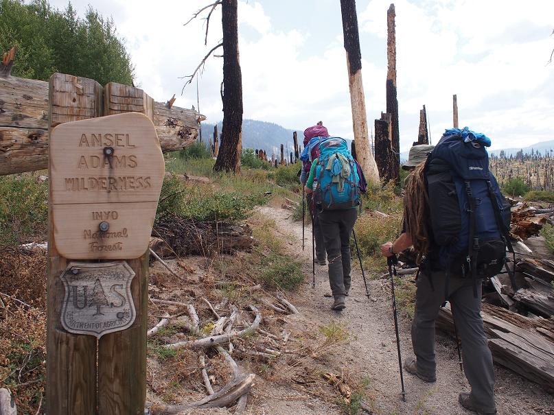
Top of the pass and entering the Ansel Adams Wilderness

We soon started getting iconic views of Banner Peak, and Mount Ritter (notable Sierra Peaks) as we headed on. The rock/geology was changing from igneous (The granite of Yosemite area) to a metamorphic landscape (more fractured/loose, dark in colour, jagged). This section I think of as the 'lake district', with Garnet Leak, Thousand Island Lake, Emerald, Ruby etc etc. The views from Island Pass (10,203ft) particularly memorable as was the high wind! I could have spent a day looking at the scenery from this point if time had allowed us the luxury. We pushed on and stealth camped at Garnet Lake (don't ask) out of the wind. At this point my MSR filter didn't really work, filtering 1ltr took 30-40 mins (later fixed). Robs Katadyn filter worked much better and didn't give him problems the whole trip. All the Americans seemed to be using 'gravity' systems which were slow but much lighter.

One of many great log bridge crossings

I could have spent a day here on Island Pass looking at the views
Abi saved the day by spotting this beastie (2-3") trying to get into Janet's bag

View down to Thousand Island Lake
One of many 'paddles' in the many Lakes!
After a cold windy night its all down hill (lots) now to Red's Meadow. Another great day with great views. Went through an area with big trees blown across the trail (blowdowns) and cleared. It reminded me that Tanya had said that last year when they did the PCT sometimes they spent a whole day going through a section of 'blowdowns' that hadn't been cleared. Must have been really tough, on the 180 miles we hiked only 2-3 tree's were across the trail and 100's had been cleared.

First light on Banner/Ritter from Garnet Lake

Must need big chainsws to keep these trails open
Harsh when the only food is me (sweat)
A great night at Reds around the fire watching the stars
 I'd been here before and had promised the group a memorable experience in the free geothermal hot showers. Wrong! They had been closed 3 years earlier because they cannot effectively be monitored for safe water quality by environmental health (sad). Red's Meadow is a cool stop after another 'bunch' of days on the Trail. There's a store, cafe, campground and Ranger station (linked by road to the town of Mammoth). We picked up our first resupply package (yay - it was here), had a shower and gorged in the cafe. Discovered 'a la mode' - basically they seem to sell fruit pie 'a la mode' all over this area and it is 'in the style', meaning basically you get a scoop of ice cream with it! Used the first hiker buckets, we put in loads of clif bars as we had far too many, and I sadly put a pair of old sandals in as I was carrying 3 pairs of footwear due to a pre-hike injury. We also took a couple of meals out of the bucket!

Just arrived, time to big up the mail (food parcel) and see what goodies are in the hiker barrel

Darn good burger (double)

Classic Americana decor in the cafe!
 So all going well after the illness scare (I was worried it was Giardi). We were all starting to feel acclimated (American term we kept hearing/were always asked about) at this point, and the routine on the trail of getting up, eating, hiking, eating, camping, eating and sleeping was becoming second nature and pleasurable for its simplicity...........but will it continue....... (of course it will, sorry next blog post soon!).


Sunday, 8 September 2013

The John Muir Trail Part 1 - Yosemite to Tuolumne

Just back from 3 weeks in California hiking on the John Muir Trail. The John Muir Trail (JMT), is one of the most famous, dramatic and iconic mountain walks in the world and I've wanted to hike it for over 10 years, ever since I first went to Yosemite climbing in 1999.

The trail starts in Yosemite Valley in the Sierra Mountains, heading South for 220 miles and finishes on Mt Whitney (14,505ft/4,421m) the highest summit in the contiguous United States. The average elevation is just over 3000m and its hot in the day, and can be cold at night. Black bears and other interesting wildlife like Coyote, Rattlesnakes should be expected on the trail (I have a poor track record with bears).

The 'normal' village store

Abi proud with her 15kg pack (looks tiny!) after getting our permits

At our pace (enjoying it) its about 21 days hiking (the record is just under 4 days - fully supported {just carrying water and running it}...but that's silly!!). So when you factor in a rest day or two, and the logistics of getting to and from the trail (no mean feat in the land of poor public transport because everyone owns an SUV), buying food and posting ahead food drops you need 4 weeks. We went with Janet and Rob, who had 4 weeks off work, but I could only get 3 weeks. Apologies in advance if I occasionally slip into American slang/drawl, but its so darn tooting easy....


wildlife is everywhere, can you spot the deer just off the road in a meadow

The Royal Arches on the left (1000ft cliff), and Half Dome dominating the view centre back (a 2000ft granite wall)
 We arrived in Yosemite after a couple of crazy days in 100F heat sorting out our logistics in the strange town of Merced (big town but couldn't find the centre - felt like a hot outdoor mall). Yosemite is an amazing place and I was 'stoked' about everyone seeing the valley, but its a real dichotomy, on one hand its an amazing unrivalled granite mountain landscape (?playground) with mile high walls towering over the valley, a mega for climbers, and I guess anyone who appreciates spectacular landscapes, but also its very theme-park-esque, with 4 million visitors a year and 90+% of those not going more than 100m from their vehicle or the themed burger/pizza joint.

We were all still shocked by the heat as we picked up our permits (no permit no hike - booked 6 months in advance) and weighed our packs on the scales outside the ranger office (that was also a shock - heavy was the theme) we headed to the backpackers camp ground - exciting, here at last after 6-8 months planning).

Camping is easy in the valley (picnic tables). But Abi didn't like the pit toilets full of hungry fly swarms!
Next day we took the shuttle bus up to Glacier Point (7,214ft - sorry its all feet here) our hike start point. From here you get unreal views of the valley and in particular Half Dome (Climbed an amazing 5.7 R route called Snake Dike on this dome in 2000, so brought back happy memories).

Starting point (Glacier Point), startling views of Half Dome (looks steep from here!)
Usually you start the JMT in the valley, but we couldn't get a permit for the original start, I think this was a blessing really, a couple more miles to walk on day 1, but starting much higher up would be easier to get used to the heat and altitude. It was great to get going, we were all excited as we slowly eased into our first day of hiking on this panorama trail carrying our heavy packs (ranging from 15-20kg with 6 days of food). The first proper night on the trail was at the brilliant Little Yosemite Valley, a suggested campsite with bear lockers and pit toilets. It was sociable, with other hikers around. We all shared a big fire, chatted and watched the stars - bliss. Originally (naively), we had planned to get much further up the trail on day 1, but when we met a ranger higher up the next day he informed us that the higher camp had been up all night trying to keep a bear and cub out of camp. We were very glad we stopped when we did.

Great trail, amazing lichens (vivid green)

Chilling at the campfire... sharing tales and toasting marshmellows
Day 2 blew our socks off, a short spectacular day as we headed away from the crowds, higher, onward to Sunrise High Sierra Camp. This is a manned 'camp' with tented cabins for paying guests {not us}, all supplies and luggage hauled in by cowboys/girls with their mule trains (for the lucky few). Started to feel the altitude here.

Rob checking out the views. A typical meadow/mountain  scene from the first 3 days (stunning or what)

Great trails head through the open meadows
Love this shot. Abi towering over the mountain...
 Day 3 - Cold morning, just below 0C, but after warming up the day just got better and better as we headed through forest and then over Cathedral Pass (9,700ft), with views of Cathedral Peak/Echo Peak and other classic mountains (climbs) in the area. Getting to Tuolumne (pronounced 'Too-arll-oh-mee') was great, because I knew that we would hit a road, shop and best of all a tented burger joint (all dismantled in winter when the snows come). Gorged on a cheese burger and fries, and slept well at the backpackers camp ground. I felt happier that we had completed a few days, it all seemed to be going well and no bears so far but would it last........?

Having a break on Cathedral Pass. Big views.

Burger please......no make it two....

Sunday, 11 August 2013

Last minute training (is not a good idea)!

We had 2 great days walking in the Lakes. I was carrying 12kg in the rucksack to see how comfortable it was, but the mistake was to wear new 'footbeds' in my new boots!

On Saturday we went on a quick blast up the Old Man of Coniston, and looped back past Dow Crag/Goats Water. 

On top of 'The Old Man'
Heading down to Goats Water (Dow Crag on the right)
 Sunday saw us going up Bowfell via Angle Tarn, and this is were the dreaded foot pain started! I now have a foot/heel injury that I'm hoping goes away soon - lots of ice and anti inflammatories (and my old boots) I think!

Rob and Abs heading over the beck to start the climb

A local  'model' in the foreground, Great Langdale beyond. Typical U shaped glacial valley with lots of drumlins at the head of the valley.
I'd not seen such fine Drumlins for ages. A drumlin, from the irishword droimnín ("little ridge"), first recorded in 1833, is an elongated hill in the shape of an inverted spoon or half-buried egg formed by glacial ice acting on underlying unconsolidated till or ground moraine. Drumlins are formed of till. They are elongated features that can reach a kilometer or more in length, 500m or so in width and over 50m in height. One end is quite step, whilst the other end tapers away to ground level. There is still some debate about how drumlins are formed, but the most widely accepted idea is that they were formed when the ice became overloaded with sediment. When the glacier reduced in size, material was deposited, in the same way that a river overloaded with sediment deposits the excess material.


Drumlins!


Nearing the top of Bowfell. Views of Scafell and Scafell Pike in the background (left side)

Saturday, 3 August 2013

Mid week bike blast

This week it was weird weather, hot, then rainy, then hot - repeat pattern.... So it was really difficult to try and decide as to whether it was worth the risk to try  climbing in the evening. Personally I didn't fancy getting stuck on a multipitch route in one of the heavy showers we have had every day. So instead of climbing Rachael and I headed out on the mountain bikes and did a brilliant route from Staveley on the edge of the Lakes, and yes got caught in a heavy shower, but that's fun when cycling. Great catch up with Rachael.

Heading deeper into Kentmere